
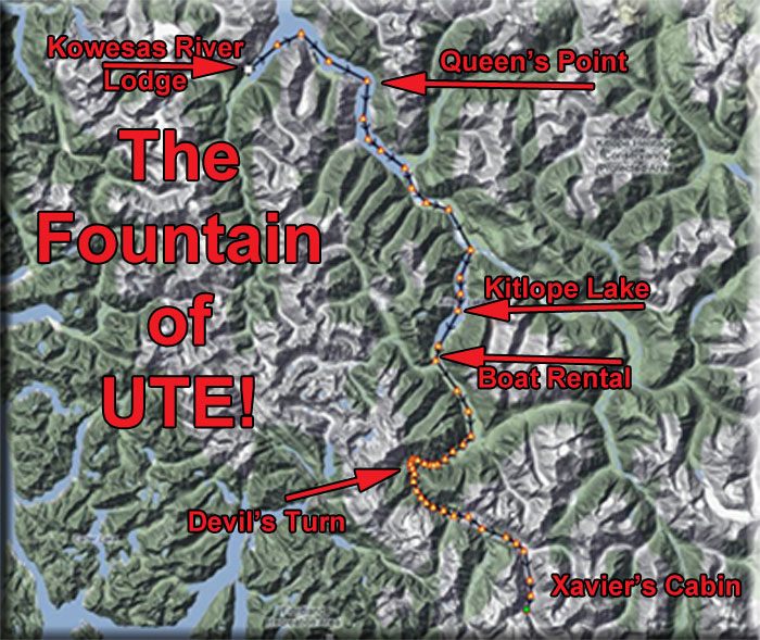
Destination: Fountain of Ute (Xavier's Cabin)
Route Briefing
- This Scenery is for "Return to Misty Moorings" only.
- Suggested Altitude: 1200-1900 Feet (See Leg)
- Landing zone is: Water - does not freeze in winter
- GPS for destination: N52 48.66 - W127 40.74
- Distance approximately: 47 Miles
- Download PRINT-ABLE copy HERE
- Flight-Seeing Flight Plan & Map HERE
- Scenery Needed: Xavier's Cabin
Fountain of Ute (Xavier's Cabin)
NOTAM: You will need two scenery packages for this flight, Kowesas River Lodge and Fountain of Ute, both found at RTMM/Scenery.
We will be flying from the Kowesas River Lodge to Xavier's Cabin in search of the Fountain of Ute. Our trip takes us into deep canyons and gorges. You can fly the flight-seeing plan with autopilot all the way if you slow down at Devil's Turn.
VFR Wavetop Plan
FROM : Kowesas River Lodge (PF10)
TO: Xavier's Cabin and the Fountain of Ute
Leg: Chief Matthews Bay to Courageau Point
Initial Course: 036
Leg Distance: 3 Miles
Leg Altitude: 1200 Feet
Take off on runway 34 and fly the length of Matthews Bay on a heading of 36 heading for Courageau point 3 miles ahead on the starboard shore. We will be rounding that point to starboard.
Leg: Courageau Point to Tezwa River
Initial Course: 120 (Follow the Reach)
Leg Distance: 10 Miles
Leg Altitude: 1200 Feet
When you round Courageau Point, you are in Whidbey Reach, follow the center of the reach on an approximate heading of 120. Queen Point will come up to starboard, you will be turning to starboard around Queens Point to about 160. In 2 miles, the reach curves to port, and you come to a centered heading of 120. Ahead, you can see the end of the reach and the beginning of the Tezwa River.
Leg: Tezwa River to Kitlope Lake
Initial Course: 120
Leg Distance: 4.3 Miles
Leg Altitude: 1200 Feet
Continue on an approximate 120 heading to stay over the center of the river basin. You will see little route marker buoys in the river. These are there for the Fountain of Ute River Run. You can do with with a watercraft. If you watch for the buoys, they will guide you to the cabin. The river curves left and right, just continue to follow the basin. When you come to a "Y" in the river, you will turn to starboard into Kitlope Lake. (Do not go straight ahead!)
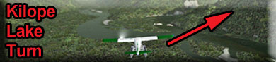
NOTAM: Watch the marine navigation buoys, they will help you with critical turns like this one.
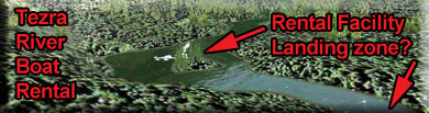
Leg: Kitlope Lake to Tezwa River Boat Rental
Initial Course: 182
Leg Distance: 11 Miles
Leg Altitude: 1200 Feet
NOTAM: There is a short landing zone at the end of this leg it is an "optional" stop. But if you are going to stop, be in landing configuration when the basin turns to starboard. It is a short and narrow water landing zone. And you will have to approach from starboard and bank left to land. If you are going to land, go to 600 feet, otherwise stay at 1200 feet.
Follow the center of Kitlope Lake in this area. When the lake comes to and end, you will be following a river basin. Again, watch the little marine buoys to know to turn to port on the branch coming up. Follow the center of the river basin. The basin makes a sweeping curve to starboard. You will see the wide basin become narrow and at that point, you will find the Tezwa River Boat Rental. It is possible to land there and look around if you want.
Leg: Tezwa River Boat Rental to Devil's Turn
Initial Course: 210 (Follow the Gorge)
Leg Distance: 3 Miles
Leg Altitude: 1200 Feet
NOTAM on Devil's Turn: If you are using the autopilot with the Flight Seeing Plan, you must reduce speed to about 65 mph (using flaps, etc) to make the turn. Be very careful on this turn ... and as the turn ends, do not make the mistake of going off to starboard, continue to port into the sharp and deep gorge.
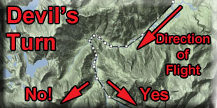
Make sure your altitude is 1200 feet. 3 miles ahead is Devil's Turn. (see NOTAM above). Once you are past the turn, you can increase your speed safely. You can continue on down the gorge to "Waterfall" ... 2 miles ahead on the starboard side.
Leg: Devil's Turn to Waterfall
Initial Course: (Follow the Gorge)
Leg Distance: 2 Miles
Leg Altitude: 1900 Feet
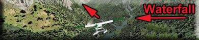
After Devil's Turn, follow the VERY NARROW gorge and begin increasing your altitude setting to 1900 feet. Continue to follow the river. A few miles ahead, you will see a river literally coming down off the mountain to starboard, that is the Waterfall waypoint.
Leg: Waterfall to Mountain Turn
Initial Course: 096
Leg Distance: 5 Miles
Leg Altitude: 1900 Feet
Increase you altitude to 1900 feet. Continue to follow the river, it soon opens up a little into a wider basin. Soon a large mountain will be blocking your way. At this mountain, the river turns to starboard. Follow the river and prepare to get into landing configuration. The landing zone is 5 miles ahead.
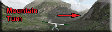
Leg: Mountain Turn to Xavier's Cabin
Initial Course: 156
Leg Distance: 3.2 Miles
Leg Altitude: Landing Configuration Altitude
You will come to a large mountain and the river turns about 90 degrees to starboard. This is Mountain Turn and you are now 3.2 miles from the landing zone. You should be at 1900 feet, meaning you are about 550 feet above the river. This is a good altitude to set up your landing 3 miles ahead. Go into landing configuration and watch carefully for the landing zone(s) below.
There are two landing zones for Xavier's Cabin:
1. Safe Landing Zone
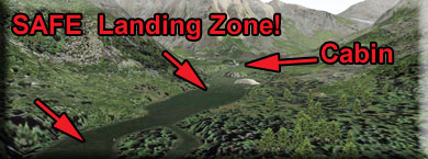
For most people, this is the landing zone they should use, it is easy to land here if you are going slow and it is only a 1/2 mile taxi to Xavier's Cabin. You will then go to the left and take a tiny channel up to the cabin.
2. Dangerous Landing Zone
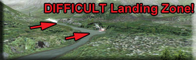
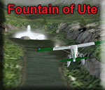
This landing zone is in front of the cabin and pointed toward the Fountain of Ute. It is a very short zone and you must approach it in a steep bank to port. Only attempt this if you "know" what you are dong!
And don't forget! You are here to check out the Fountain of Ute! It's just down the channel from Xavier's Cabin.
Welcome to Xavier's Cabin and the Fountain of Ute!
Doug Linn
Charter Manager
Misty Moorings, Inc
contact@mistymoorings.com
(Added: 07.10.2012)
Copyright Return to Misty Moorings 2012